How To Find Your Property On FEMA’s Flood Insurance Rate Maps

What are FEMA flood maps?
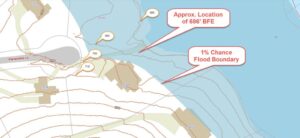
FEMA’s Flood Insurance Rate Maps (FIRMs) or just Flood Maps are provided after a flood risk assessment has been completed or updated for a community.  This study is known as a Flood Insurance Study.  The FIRM gives you the Base Flood Elevations (BFEs) and insurance risk zones in addition to floodplain boundaries.  The FIRM may also show a delineation of the regulatory floodway.

Once the “insurance risk zone”  (commonly referred to as the flood zone) is determined, actuarial rates, based on these risk zones, are then applied for newly constructed, substantially approved, and substantially damaged buildings.  FEMA uses these rates to determine the insurance rate you will pay for flood insurance

FEMA’s Digital Flood Maps

FEMA discontinued the production and distribution of paper flood maps in 2009 as part of its Digital Vision Initiative. This affected all the Flood Maps, boundary information, and study reports. However, clients can still view the products for free through their website or buy them in digital format.

To view these flood maps online, go to FEMA’s Map Service Center and key in your address (hi-lited area shown here) search for your home.  This will prompt you to then select the map that covers your area.  The Flood Maps are somewhat cumbersome to use online. It is best to go through the tutorial on the bottom right of the address search page for an easier and more effective use of the GIS map.
author avatar
Surveyor

More Posts

Land surveyor using total station on muddy ground after flood to update an ALTA Land Title Survey
alta survey
Surveyor

ALTA Land Title Survey for Post-Flood Recovery

When the recent floods swept through parts of Colorado, including areas not far from Colorado Springs, they didn’t just leave muddy streets and damaged yards. They changed the ground itself. Creek banks shifted, low spots deepened, and drainage paths that never existed suddenly appeared. For many homeowners and property investors,

Read More »
Land surveyor updating flood elevation certificate readings after storm
flood damage
Surveyor

Update Your Flood Elevation Certificate After Storms

Colorado Springs homeowners are on edge. After last week’s “unprecedented” flooding in southwestern Colorado, insurance companies are asking property owners to update their flood elevation certificate even if their homes weren’t touched by floodwater. Why? Because big storms can change floodplain maps and force new elevation checks across the state.

Read More »
Land surveyor using tripod equipment beside a highway construction site, demonstrating how alta surveys support accurate planning and major development projects
alta survey
Surveyor

Why ALTA Surveys Matter for Major Developments

Earlier this month, people all over southern Colorado were talking about one thing — the plan to build a Buc-ee’s in Palmer Lake. Some people were excited about the famous travel stop coming to town. Others were worried about traffic, noise, and how much the area would change. But for

Read More »
Aerial view of suburban neighborhood with property lines overlaid showing how property line surveys define land boundaries
boundary surveying
Surveyor

Property Line Surveys and Annexation Disputes

If you’ve been on Reddit or following local headlines lately, you’ve probably seen the debate over the proposed Buc-ee’s in Palmer Lake. The project has stirred up heated arguments about water, traffic, and even an 80-foot sign. Yet behind all the noise lies a less flashy but very important tool:

Read More »
Surveyor using a total station for a construction staking survey on an undeveloped site with workers marking ground locations
construction
Surveyor

Construction Staking Survey Insights Amid Permit Freezes

When news broke that Colorado Springs issued zero apartment permits in July and August 2025, many people focused on what it meant for renters and developers. But there’s another side to the story—how this sudden pause affects the survey crews who set projects in motion. A construction staking survey is

Read More »
Drone surveying at sunset with operator controlling flight, showing how geomagnetic storms can impact GPS accuracy
land surveying
Surveyor

Drone Surveying Challenges During Geomagnetic Storms

Drone surveying has become one of the most powerful tools for engineers, builders, and developers. Crews rely on drones every day to map subdivisions, check construction sites, and capture accurate ground data in a fraction of the time it used to take. But this week, many teams saw something unusual:

Read More »